South Galiano Loop
Tuesday, September 12, 2006
We set off the day after Labour Day to explore a loop trail around the South of Galiano Island, I wanted to visit Matthews Beach, head up the escarpment edge to the Bluffs and then come back through the woods to the ferry. This seemed likely to be a three-hour trip and by taking it leisurely on a hot clear sunny day, we could easily stretch it to four.
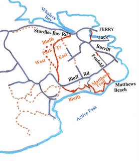
 Our ferry left 35 minutes late, which was only 15 minutes later than normal after a weekend. We got into Sturdies Bay about 11:45 which still gave us an ample six hours for our day on the island. We headed along the pier’s pathway and I saw a group of older hikers hurrying ahead of us. They crossed the road immediately they reached land and headed down to the beach. I decided to follow and see what route they took. We crossed the beach {it was low tide) turning in to the cliff at the last house on the north side. Here a well-worn path through the dry long grass lead us to a driveway and to Jack Road just by its intersection with Burrill.
Continuing briefly on Burrill, we turned into Lions Park at the Medical Clinic sign and looked around the park and skateboard ramps. Sure enough, I found what I wanted - a trail through to Penfold Road. We took it and made a short cut to Bluffs Road. We turned right and in a few minutes found a Beach Access trail signed on the left, taking us to the top of an escarpment overlooking Active Pass. A steep trail led down and ropes provided assistance to reach the beach. Here we sat and had our lunch and enjoyed the beach and the passing marine traffic for some time. A coastguard vessel passed, Vancouver and Victoria ferries went by, their paths meeting under the bluffs further west. The Bowen Queen serving local Gulf Islands traffic passed westward in front of us.
 After lunch, we went back up the rope-assisted trail and when we reached a sharp red-taped turn to the right, we headed off on the path to the left. This sidehilled across the slope and eventually came out to a track angling downhill. A sign on the right requested no trespassing and fallen logs and branches across the track to the left suggested it was not a promising route. Then we saw that there was a trail continuing uphill on the other side of the track. This switchbacked up and again was rope assisted on some of the narrower parts. It continued on through forest and eventually led out to a microwave tower at Matthews Point with a view over Active Pass.
After enjoying the view we continued uphill to Salalkum Point where a quintet of flags announced the summit. The trail then continued down to a track, where a jog left led almost immediately to a short path through the broom onto another track. This led up past an old deserted house and continued onto the escarpment which we followed to the Bluffs Park parking lot. Here we chatted with a group of visitors from various countries who marvelled that people of our advanced age could make it all the way from the ferry. At the summit hut, we stopped and had another break, sitting looking over the edge at the ferries below.
To return to Sturdies Bay, we continued further along the trail to reach Bluffs Road, which we followed briefly, taking the first trail into the swordfern on the right. We followed this uphill and branched right down Bluiffs Park East Trail when it joined on the right. This led us through pleasant woods to the Sturdies Bay Trail arch and then by road into the little town. Many shops were closed for holidays or because it was Tuesday. But we found the bookstore was open. We looked round it, bought a useful Galiano map and then went to the ferry terminal and waited for the ferry which arrived when expected.
Return to Further Walks.
Archives
![]()